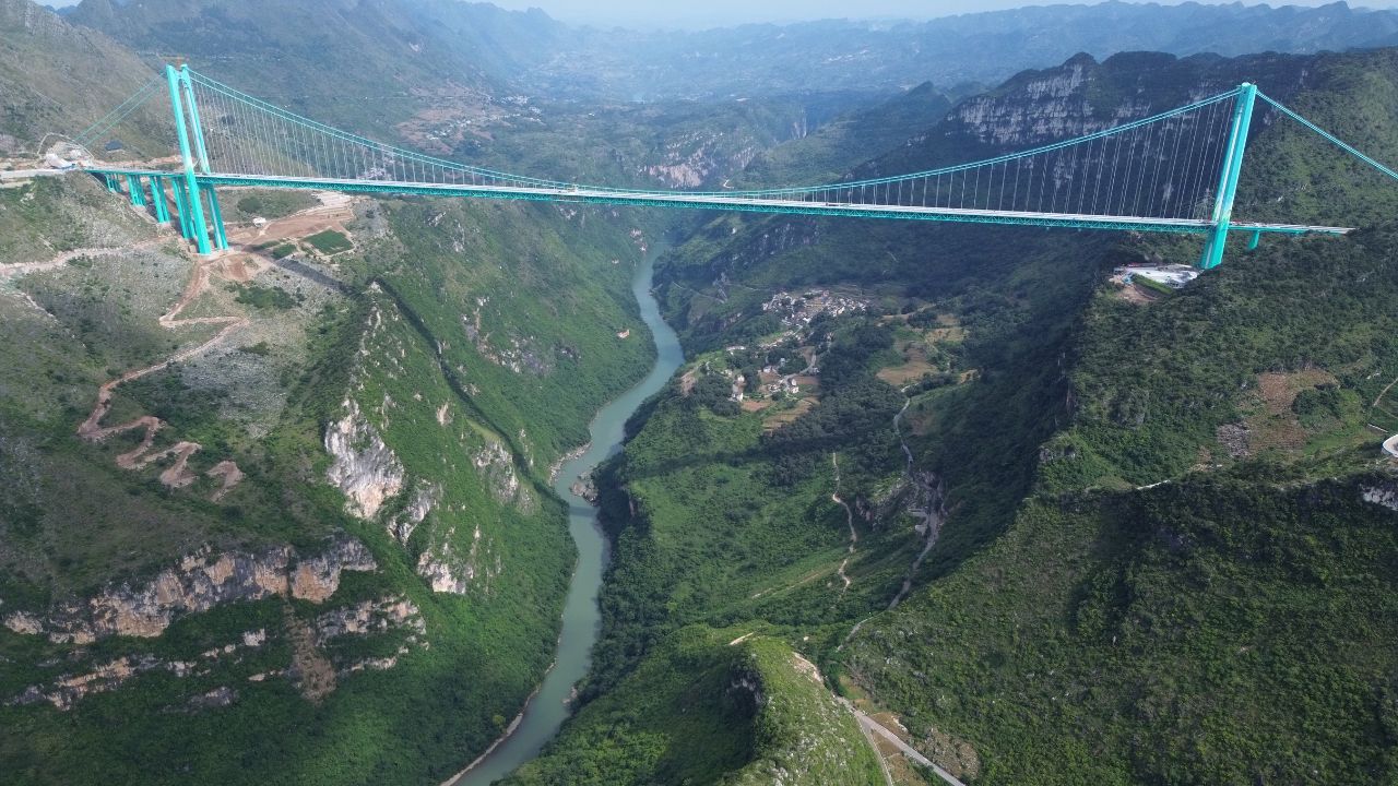
A new suspension bridge in southwest China just changed the map. The Huajiang Grand Canyon Bridge in Guizhou opened to traffic and now holds the record for the world’s tallest bridge by deck height above the ground. Drivers who once crawled around a rugged canyon for roughly two hours can cross the span in about two minutes. For anyone who loves engineering or epic views, this is one of those moments when numbers meet real life.
The bridge soars over the Beipan River, a deep cut through Guizhou’s mountains. It connects communities that were close in miles but far in travel time, and it turns a nerve-wracking detour into a fast, direct hop. Here is how it works, why it matters, and what the record really means.
Meet the record breaker
The Huajiang Grand Canyon Bridge is a four-lane suspension bridge that carries the Liuzhi to Anlong expressway. Its deck sits about 625 meters, or 2,050 feet, above the river at the bottom of the gorge. That number is what pushes it to the top of global rankings. In bridge language, this is the “height” from deck to ground or water below, not the height of the towers themselves.
The structure stretches roughly 2.9 kilometers in total length, with a main span of about 1,420 meters. Those figures place it among the world’s elite long spans, especially in a mountainous setting where anchors, cables, and wind all get trickier. Construction began in 2022, load testing wrapped in late summer 2025, and the bridge opened at the end of September.
For context, France’s Millau Viaduct still has the tallest bridge towers on Earth, but the deck does not hang as far above the valley floor as Huajiang. China’s own Duge Beipanjiang Bridge previously held the “highest deck” mark, and it also crosses the Beipan River upstream. The new bridge is a fresh chapter in a region that has quietly become a world lab for extreme canyon crossings.
How engineers pulled it off
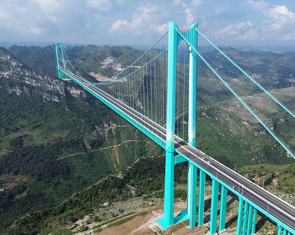
A bridge this high needs a careful plan, constant monitoring, and checks that prove the math. Crews built tall pylons to anchor the main cables, then strung those cables across the canyon before lifting deck sections into place. The site’s topography created challenges that flatland projects never face, including wind patterns that change with depth and a long vertical drop that complicates rescue and maintenance plans.
Before opening day, the structure underwent load testing with dense lines of heavy trucks and hundreds of sensors tracking how the deck flexed and how the cables behaved. Those tests are standard on big spans, but the stakes feel higher when the river is far below. Engineers also checked temperature effects, since steel contracts and expands across long distances. A bridge that feels light in summer sun must also be steady in mountain cold.
Maintenance planning is a quiet hero here. Crews will use catwalks, access points, and inspection vehicles to watch the deck, the suspenders, and the towers over time. With winds and fog in the mix, the work is as much logistics as it is measurement. Routine checks keep a record of how parts age, which supports timely repainting, cable inspections, and bearing replacement.
Highest, tallest, or longest
People mix these terms all the time, so here is a quick decoder. “Highest bridge” usually means the greatest distance from the deck to the ground or water below. “Tallest bridge” sometimes refers to the tallest towers, like Millau’s 343-meter masts. “Longest span” means the single biggest gap between towers, not counting approach viaducts. Huajiang’s record is about deck-to-river height, which is what makes the photos feel so unreal.
What a two-minute crossing changes
Shaving a two-hour drive to about two minutes is not only a cool stat. It changes daily life on both sides of the canyon. Ambulances can move faster. Students can commute to schools that were once impractical. Farmers and small businesses can reach markets without planning half-day trips. In rugged places like Guizhou, that kind of crossing unlocks simple errands that used to require careful scheduling.
The bridge also spreads out traffic that once funneled through narrow mountain roads. Fewer hairpin climbs means fewer chances for accidents and road closures, especially in wet season. Drivers will still need caution in crosswinds and fog, yet the crossing becomes predictable. For long-haul travelers, the direct route slots into a network of expressways that link interior provinces to coastal hubs.
There is a tourism ripple too. View pullouts, glass walkways, and other scenic stops around the canyon now make more sense because they sit near a major artery rather than at the end of a long detour. That does not mean the region becomes an amusement park. It means visitors can spend time on trails, viewpoints, and towns instead of burning hours on hairpin turns.
Why Guizhou keeps showing up in bridge news
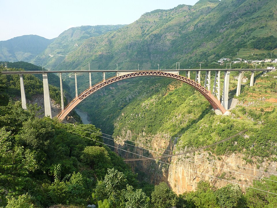
If you follow big bridges, you see Guizhou again and again. The province is full of deep limestone gorges and isolated plateaus, which create huge height differences over short horizontal distances. Engineers call that tough geometry. The upside is that the span lengths are finite, yet the drop is immense, which is perfect territory for record deck heights.
Over the past two decades, China built a network of expressways through these mountains using tunnels, viaducts, and suspension bridges. Duge, Pingtang, and now Huajiang are part of that pattern. Each project teaches something for the next one, like faster ways to string cables in hard terrain, better corrosion protection in humid air, and smarter monitoring so crews know when to step in long before small problems grow.
For teens thinking about engineering, Huajiang is a great case study. It blends physics you learn in class with field constraints like wind, weather, and access. It shows how data from sensors turns into real decisions about load limits and maintenance schedules. And it proves that design is not just math, it is also geography and human need.
Visiting safely, and what to look for
If you ever travel in this region with family, plan like a local. Weather shifts quickly in the mountains, so check conditions and avoid foggy hours. Use official viewing points rather than stopping on the shoulder. Railings and signed overlooks exist for a reason, and maintenance crews need shoulders clear for inspection vehicles.
Bring a good camera or a phone with a wide angle lens. The deck height is so extreme that your brain wants context. Framing the river and one tower base in the same shot helps you feel the scale. If you are into construction details, look for the suspenders that run from the main cables to the deck. Notice how they change spacing near towers and midspan. You are watching physics made visible.
Finally, give yourself time to enjoy the crossing. It is quick, but the approach viaducts and cable curves are worth a look. Bridges are built to move people, yet they also teach us how a hard place becomes a connected place. That is the quiet part of this record. It is not just the height. It is the way a canyon stopped being a daily barrier.
Sources
- Reuters video (September 2025). “World’s tallest bridge opens to traffic in China, state media says.”
- People Magazine (September 2025). “World’s Tallest Bridge Officially Opens to Traffic, Cutting Travel Time from 2 Hours Down to 2 Minutes.”
- NDTV (September 2025). “World’s tallest bridge opens in China, cuts travel time from 2 hours to 2 minutes.”
- Times of India (October 2025). “China unveils the world’s tallest bridge, Huajiang Grand Canyon.”