Across 2025, extreme weather showed up not just in charts but in images that were hard to forget. Satellites captured rivers that no longer fit their banks, fire lines crawling toward suburbs, and heat shimmering over city streets. Local photographers stood in smoke, floodwater, and shelter gyms to record quiet, human moments behind the headlines. Together, these photos turned distant climate talk into something immediate, showing how quickly familiar places can shift when the atmosphere tilts out of balance.
Fire Front Above Los Angeles
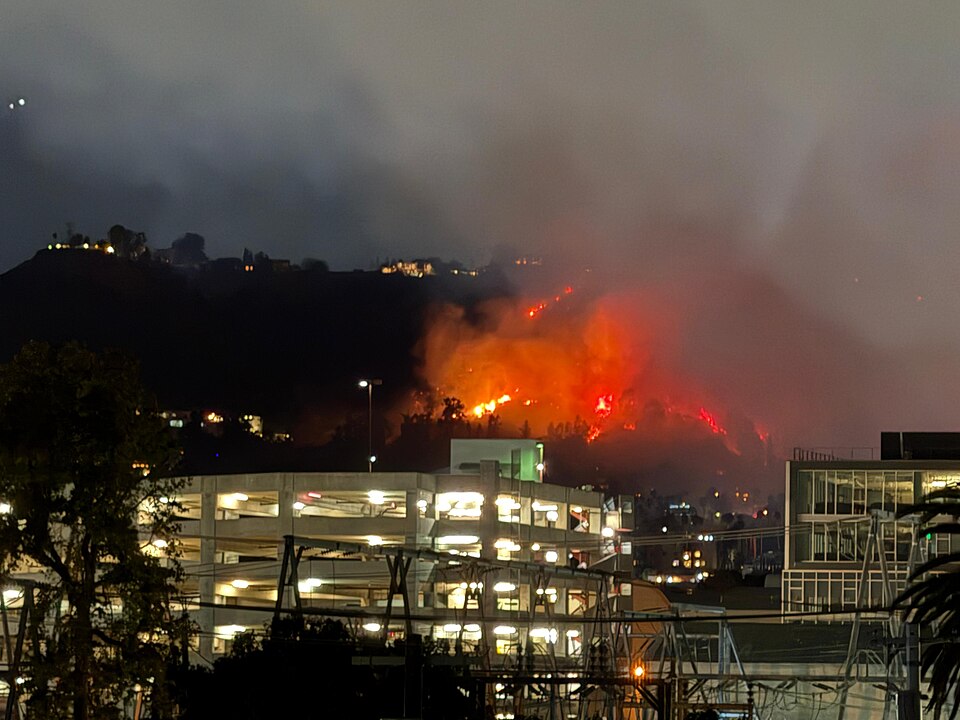
An aerial shot of the hills above Los Angeles shows a wall of flame crawling along the ridgeline, with tidy streets and cul de sacs spread out directly below. Smoke pushes over the city like a low ceiling while water dropping aircraft look tiny against the fire front. The photo captures how close the 2025 winter wildfires came to dense suburbs and how narrow the line felt between a near miss and a neighborhood gone. It turns an abstract fire map into something painfully concrete.
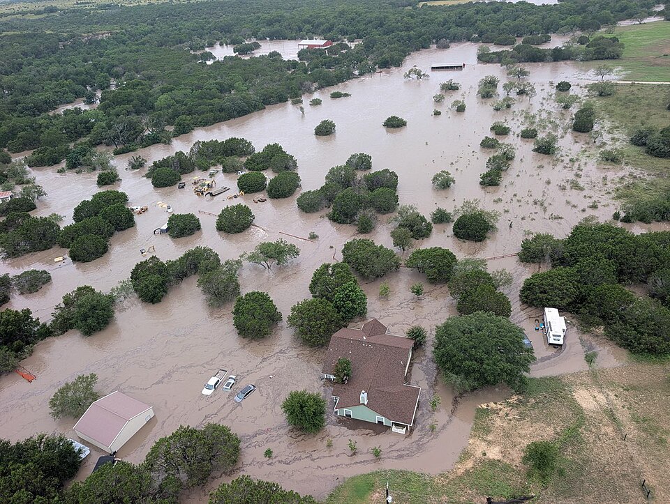
Texas Hill Country Turned Into A Brown Sea
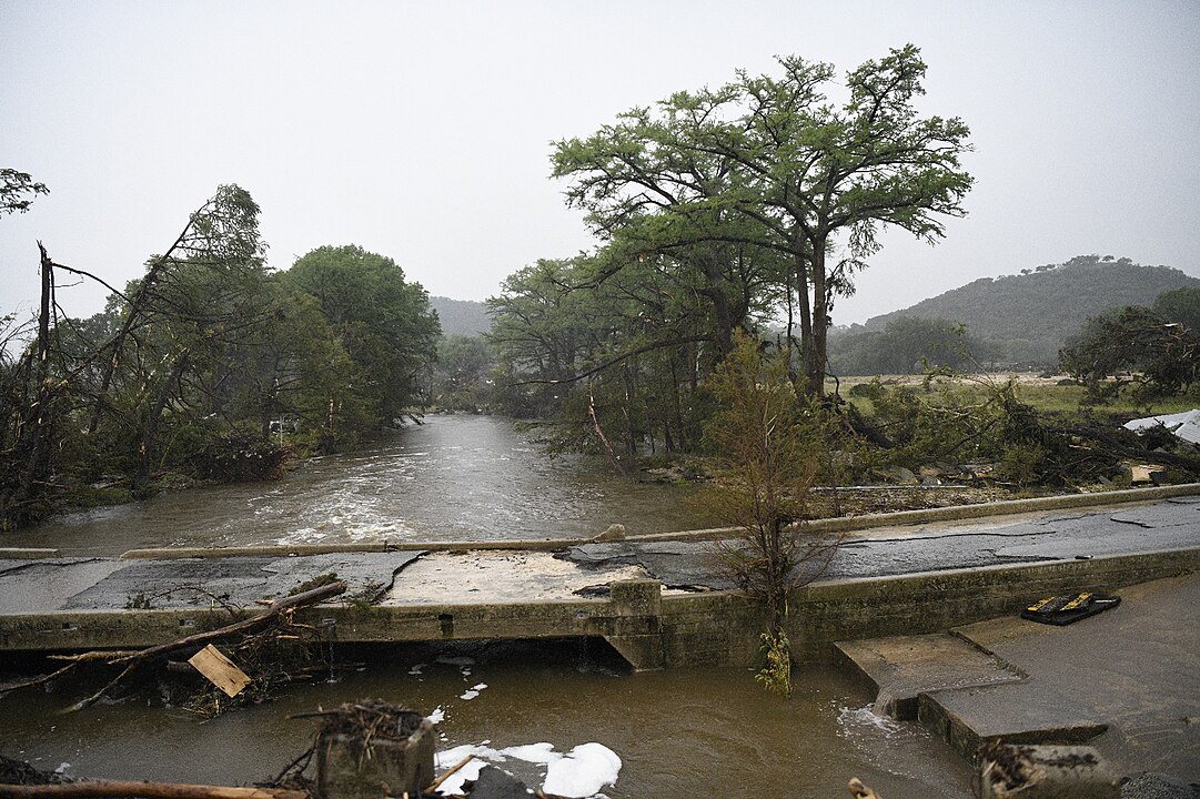
From orbit, the Texas Hill Country looks less like rolling ranchland and more like a single broad lake after the July floods. Only rooftops, tree tops, and highway overpasses rise above the brown water that covers campgrounds and river towns. The image freezes the moment after the rivers escaped their banks and hints at why evacuations failed so quickly when levels jumped in a matter of hours. It shows just how little time some families had to move.
Queensland’s Outback Under Glassy Floodwater
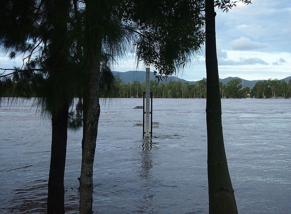
A satellite frame of inland Queensland shows long, silver sheets of floodwater pooling in shallow depressions across the outback. Farm tracks vanish beneath the reflective surface so completely that it is hard to tell where roads once ran. On a map it looks quiet and almost beautiful, yet residents on those tiny islands of higher ground are cut off from supplies, power, and medical care for days at a time. The distance in the image hides very human stress.
Market Stalls Drowned In Jakarta’s Streets
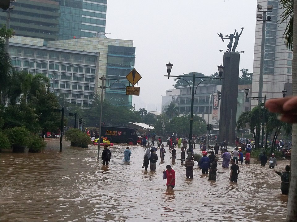
One Jakarta street scene shows a familiar market lane turned into a slow moving canal after another night of extreme rain. Vendors wade through chest high water to rescue crates, while scooters lie on their sides with only mirrors and handlebars above the surface. The frame distills a larger story of a coastal city wrestling with sinking ground, stronger storms, and drainage systems that can no longer keep up. It feels like a snapshot from a future that arrived early.
A Nigerian Town Submerged Overnight
Over Mokwa in Nigeria, a drone image shows rows of tin roofs floating in muddy water where streets and courtyards used to be. Clusters of residents stand on school steps and the tops of concrete walls, surrounded by scattered furniture and livestock that did not survive. The quiet stillness of the picture hides the speed of the flood that arrived before dawn and erased an entire market day in minutes. It is a calm frame built on sudden chaos.
A European City Shimmering Under Deadly Heat
A midday image from Madrid shows a tram platform almost empty while heat haze bends the tracks and blurs the buildings behind. A digital sign glows with a temperature above forty degrees, and a single commuter waits in a thin strip of shade. The scene looks calm, yet hospitals nearby are filling with older residents and workers who simply cannot shed enough heat in nights that never really cool down. It is a quiet picture of a loud emergency.
Greece Framed By Flame And Smoke
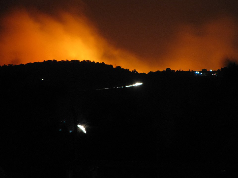
On a Greek island hillside, a nighttime long exposure shows a ring of orange fire closing in behind whitewashed homes and a small church tower. Car headlights form a slow chain down the only road toward the harbor as residents evacuate under a sky crowded with sparks. The image offers a stark view of how summer tourism towns now find themselves at the edge of large, fast moving fires each year. It compresses fear, beauty, and urgency together.
South American Forests Lit From Within
Across parts of Chile and Argentina, a twilight photo shows dense forest glowing from the inside as crown fires run through pine and native trees. Firefighters in silhouette stand at a break line that looks far too small for the wall of flame approaching. The shot explains why seasonal smoke plumes spread across borders and why communities downstream report ash on cars hundreds of miles from the fire line. It hints at how wide the impact zone really is.
An Indian Village Between Drought And Flood
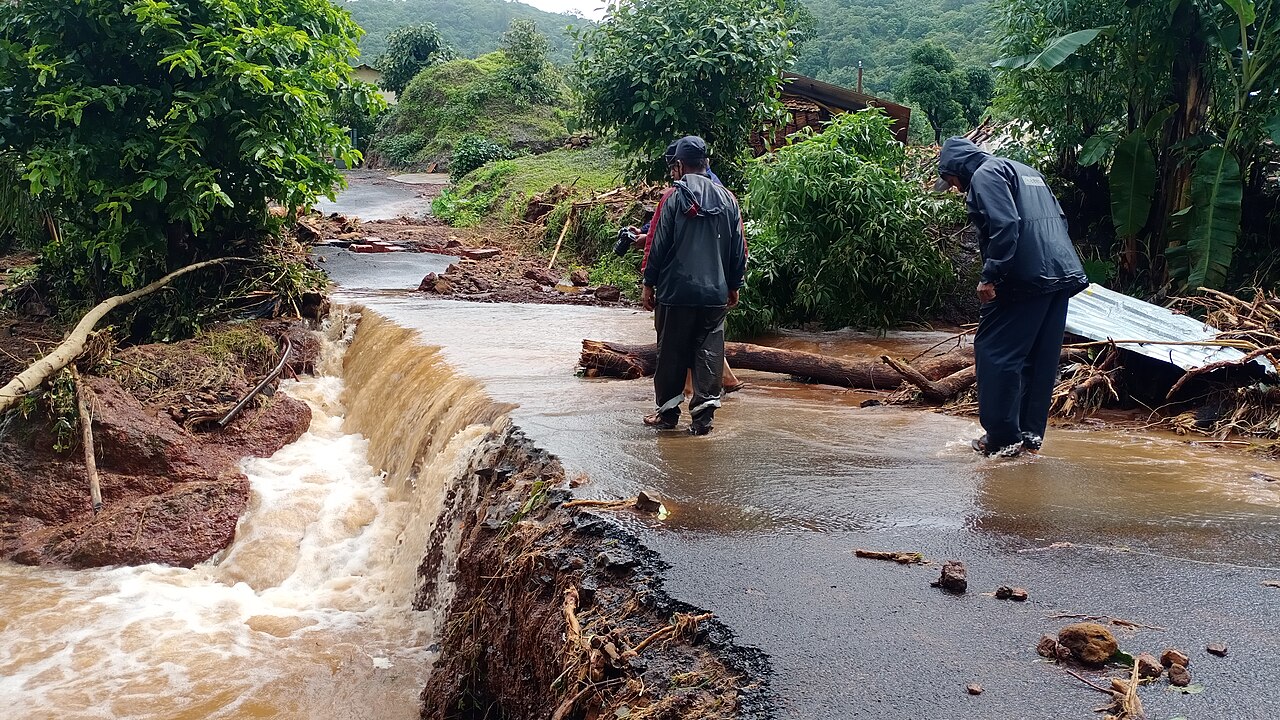
In rural India, a single frame shows deep cracks in a field where soil dried and split, with a new line of standing water cutting across the foreground after a sudden storm. A farmer and child stand at the edge, pointing toward flattened crops and a damaged embankment. That contrast in one scene mirrors a year when heatwaves, cloudbursts, and floods often arrived so close together that recovery never caught up. The picture tells a whole season in one glance.
Jakarta’s Cloud Seeding Plane And Towering Storms

A telephoto image captures a small propeller plane climbing along the flank of a huge storm cloud above Indonesia during a cloud seeding mission. The aircraft trails a faint plume as it releases particles meant to change where rain will fall, dwarfed by the dark, rising towers of vapor beside it. The shot feels like a visual question about how much control people can really exert over systems of that scale. It is both hopeful and uneasy at once.
Global Temperature Map Glowing Red
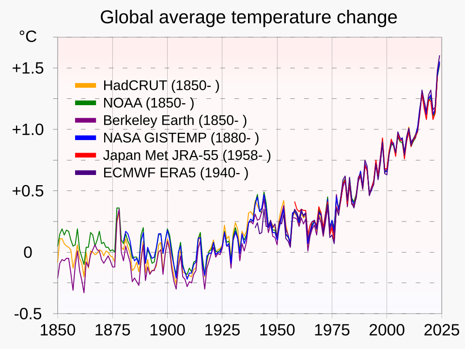
One widely shared graphic from 2025 shows a map of the world colored in deep reds and purples where temperatures ran far above average. Only a few scattered patches of blue break the pattern, mostly in isolated ocean zones. Even without numbers, the image makes the year’s records tangible and links distant fires, floods, and heatwaves to the same underlying shift in the planet’s long term thermostat. It looks less like data and more like a warning.
Families In A Texas Shelter Gym
Inside a Central Texas school gym, rows of cots fill a basketball court beneath banners from old state tournaments and pep rallies. A family sits together on one mattress, sorting donated clothes and chargers while children play a quiet board game nearby. The photo shows the softer edge of disaster, where survival looks like fluorescent lights, borrowed blankets, and neighbors figuring out what comes next. It is a portrait of both loss and stubborn community.